🌲 Humber West Trails & Humber Grove Hike – Sat. May 2, 2026
Explore riverside trails, local history, and changing landscapes west of Bolton
📅 Date: Saturday, May 2, 2026
🕘 Start Time: 9:00 AM
📍 Meeting Location: Parking lot near Duffy’s Lane and Emil Kolb Parkway
📌 GPS Coordinates: 43.888416, -79.773631
🚶 Hike Distance: Approx. 8 km
⏳ Duration: About 3 hours (plus 30–45 minutes for breaks)
🥾 Difficulty: Moderate – mostly flat, but potentially muddy
🌲 Trail Conditions: Mix of dirt roads and narrow trails; may be wet after rain
Join us for a spring hike along trails south of the Humber, west of Bolton. This route follows a mostly flat landscape through a mix of riverside paths and wooded areas, offering a relaxed but engaging walk as the season continues to unfold.
Along the way, we’ll explore an area shaped by both natural forces and human history. In one location, a road approaches the river at a low bank — possibly a former crossing point used by farmers accessing fields on the opposite side, a reminder that historical property lines often ignored the natural course of the river. We’ll also visit the Humber Grove area, where a number of buildings once stood, adding another layer of local context to the hike.
🔁 This hike is a loop-style route, starting and returning to the Duffy’s Lane / Emil Kolb parking area.
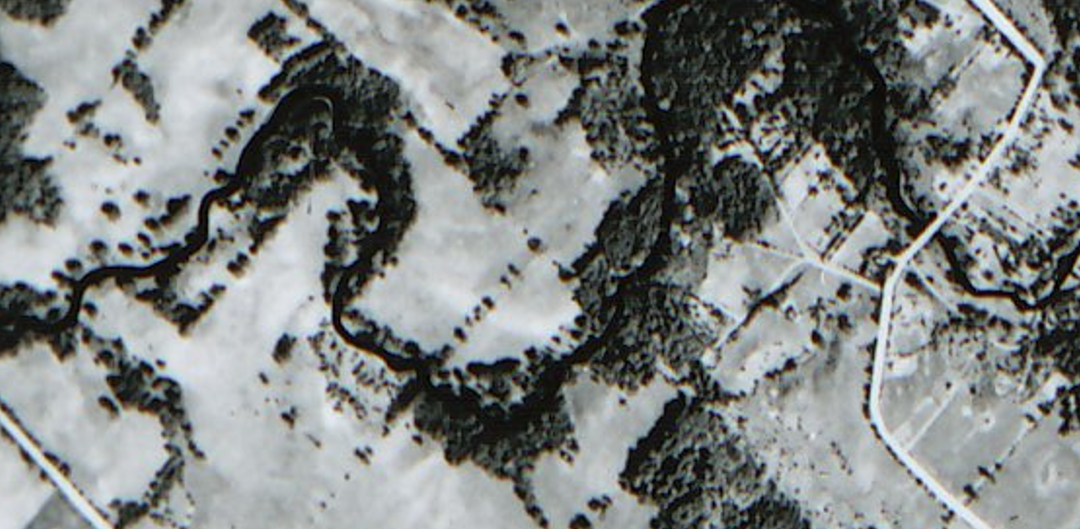
📷 Historical Note:
A 1954 (pre-Hurricane Hazel) aerial photo of this area shows a landscape that once included numerous cottages along the river. The route of today’s hike passes through parts of this former community, offering a chance to reflect on how significantly the Humber Valley has changed over time.
✅ What to Bring:
Sturdy hiking boots (water-resistant recommended)
Hiking poles (helpful in muddy sections)
Water and a snack
Layered clothing suitable for spring conditions
👟 This hike is suitable for hikers comfortable with moderate distance and variable footing.
Hike Leader:
Ron Macnaughton
Directions:
Destination: Parking lot near Duffy’s Lane and Emil Kolb Parkway
GPS Coordinates: 43.888416, -79.773631
From the south (Bolton / Kleinburg):
Take Hwy 50 north to King Road.
Turn left (west) onto King Road.
Turn right onto Duffy’s Lane and proceed north.
Follow signs toward Emil Kolb Parkway; parking is near the intersection.
From the north (Schomberg / Hwy 9):
Take Hwy 27 south toward King Township.
Turn right (west) onto King Road.
Turn left onto Duffy’s Lane and proceed north.
Continue toward Emil Kolb Parkway; parking is near the intersection.